Cartographic Design
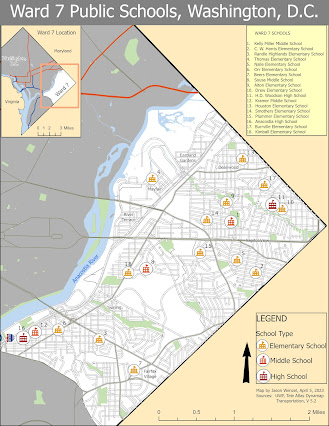
This week’s module in GIS 5007 covered cartographic design principles where we were directed to produce a map of public schools in Ward 7 of Washington, D.C. One of the main objectives of the assignment was to employ Gestalt principles of perceptual organization related to cartographic design. By employing visual hierarchy, I made sure to give the thematic symbols and type labels the highest priority. I clipped the Ward 7 schools from the DC schools layer, and then assigned unique symbological values to elementary, middle, and high schools by using three distinct school house icons from small to large respectively. For the three school types, I used red-orange fonts then set the size for each at three different levels (Tuscan red 26 pt for high schools, Flame red 24 pt for middle schools, and Seville orange 22 pt font for elementary schools). Each school was labeled with a number that corresponded with a list place in the top right corner. Each school was labeled ...