Python Environments and Flowcharts
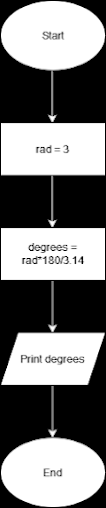
This week is GIS programming, I learned the basics of pseudocode, flow charts, and the Python programming language. For the exercise, I interpreted my first snippet of Python syntax by using the Python command prompt in the ArcGIS virtual environment. I then created and ran my first Python script using IDLE to interpret the same syntax from the previous task “Hello World.” Next, I learned about ArcGIS notebook by using the “Hello World” syntax. Finally, I created a flow chart to depict the workflow for scripting and interpreting the “Hello World” syntax and then exporting it as a .PNG. Following this, I began the Module 1 activity where I was tasked with scripting a code and developing a flowchart for converting 3 radians to degrees. I scripted the code to convert 3 radians to degrees in IDLE and used Zen Flowchart to produce a .PNG of the latter task: Then, I scripted a code to convert 3 radians to degrees in IDLE: In addition, we were request...