Posts

Showing posts with the label GIS 5103

Geometries

Image
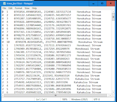
This week concludes GIS Programming, and for our final module I learned about working with geometries.  For the assignment, I developed a script that pulled geometric data from a polyline shapefile to a text document. Below is a screen capture of part of the text document that shows 247 vertices from 25 different river features.  Each row contains the following information: Feature ID, Vertex ID, X & Y coordinates, and the river feature's name. Here is a brief flowchart showing the steps followed in developing the script: Overall, I found this lab helpful in terms of gaining knowledge in how Python, ArcGIS, and a text document can be used together. This lab was difficult and challenging to complete and much of this had to do with confusion over the proper search cursor to use, the role of geometry tokens, and structuring the script with the correct level of nesting and indentation.   I am pleased to say that at the outcome of this lab, however, that I cam to a good ...

Exploring and Manipulating Data

Image
This week in GIS Programming we learned about exploring and manipulating data. For the lab assignment, I developed a script that created a geodatabase with a dictionary of county seats in New Mexico and their population in 2020. The flowchart shows the processes I followed in undertaking this task including: importing modules and classes, and setting the overwrite Output, creating a file geodatabase (FGDB), defining a variable to a feature class list, creating a for loop to copy all features to the new FGDB, creating a search cursor to be able to populate a newly created dictionary, printing the dictionary, and finally exporting the file from ArcGIS Pro Notebooks as a Python script: Featured below are screenshots showing a successful execution of the script from IDLE, of which I was very pleased to accomplish on the first run!   I enjoyed completing this lab, and it was my favorite so far!   Just like last week, I appreciated learning more about the direct interplay of ArcGI...

Geoprocessing

Image
This week in GIS Programming we learned about geoprocessing.  The assignment included two main parts:  designing a model and writing a geoprocessing script.  For the first task, I used ModelBuilder in ArcGIS pro to develop a model that incorporated two different variables (basin and soils) and used three different tools:  clip, select, and erase. At the outcome, I created the model below which essentially produced a polygon on the map frame that showed areas of non-prime farmland from a basin feature cut from a larger soils layer: For the last task, I wrote a geoprocessing script that essentially added XY coordinates to point features in a shapefile, created a buffer of 1,000 meters around each point feature, then dissolved the features into each point. The screenshot below shows the output of the script I wrote showing that each of these three processes were successfully executed:   I enjoyed completing this week’s module as it was my favorite so far. This is...