Geoprocessing
This week in GIS Programming we learned about geoprocessing. The assignment included two main parts: designing a model and writing a geoprocessing script. For the first task, I used ModelBuilder in ArcGIS pro to develop a model that incorporated two different variables (basin and soils) and used three different tools: clip, select, and erase. At the outcome, I created the model below which essentially produced a polygon on the map frame that showed areas of non-prime farmland from a basin feature cut from a larger soils layer:
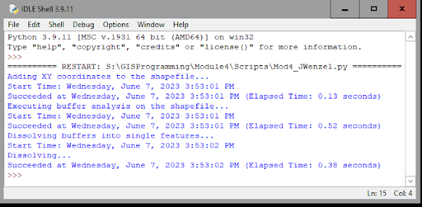
For the last task, I wrote a geoprocessing script that essentially added XY coordinates to point features in a shapefile, created a buffer of 1,000 meters around each point feature, then dissolved the features into each point. The screenshot below shows the output of the script I wrote showing that each of these three processes were successfully executed:
I enjoyed completing this week’s module as it was my favorite so far. This is because we worked more directly with the ArcGIS software, and I already had some prior experience working with some of the geoprocesses in other classes. I also feel that my understanding of Python and GIS programming in general is progressing, and this too provided me with some knowledge (and confidence) in completing the assignment. I did not encounter too many difficulties in completing this assignment. The only troubles I had was structuring the script (in terms of assigning attributes, using tools, and setting file paths) but after reviewing some of the suggested pages on the ESRI site, I was able to resolve these.
Overall, I felt that this week’s lab was helpful in improving my skills and overall understanding in GIS programming. I look forward to seeing what next week brings!


Comments
Post a Comment