Posts

Showing posts from January, 2023
Image
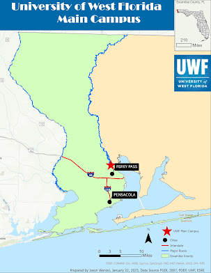
For this week in GIS 5050, I completed a cartography lab (#2) where I produced a map showing the location of the main UWF campus.  I used light colors (green, yellow, and blue) that are easy on the eye.  I used Broadway font in the title for some fun.    I did not have too much difficulty completing the lab except for when I had to select two Escambia County cities (Pensacola and Ferry Pass).  In the attribute selection I kept incorrectly using "AND" instead of the "OR" expression.  I finally figured it out, and after that it was smooth sailing onward.
Image
Today I created used GIS Pro for the first time in GIS 5050.  I created a crude map of the world.  I had trouble trying to fit the entire boundaries into the layout so the very left and right margins got cut off.  I expect to learn this task sometime later in the course.  

My GeoJourney begins today!

Image
                                             In Spring 2023 I began the graduate certificate in GIS at the University of West Florida.  The first and current class I am taking in the program is GIS 5050, Geographic Information Systems.  One of the first course assignments requires students to create a blog that they will use not only for this class, but future ones in the certificate program.  While I have yet to start work on my own GIS projects for class, I thought I would share one from my course project in the last GIS class that I took (GIS 5107) at the University of Florida ins Spring of 2010. This map shows the distribution of graves and artifacts at the Old Oakland Cemetery in Oakland, Orange County, Florida and the site's proximity to Highway 50 and a sinkhole immediately to the northwest.  The map also shows contour lines and the chain-length perimeter fence.