Geometries
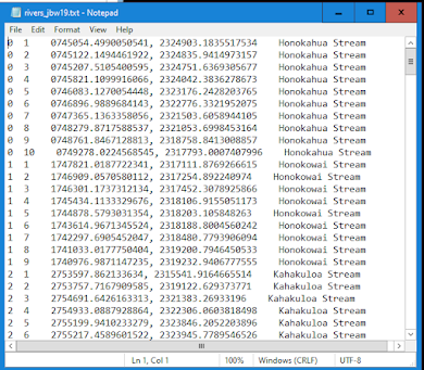
This week concludes GIS Programming, and for our final module I learned about working with geometries. For the assignment, I developed a script that pulled geometric data from a polyline shapefile to a text document. Below is a screen capture of part of the text document that shows 247 vertices from 25 different river features. Each row contains the following information: Feature ID, Vertex ID, X & Y coordinates, and the river feature's name.
Here is a brief flowchart showing the steps followed in developing the script:
Overall, I found this lab helpful
in terms of gaining knowledge in how Python, ArcGIS, and a text document can be used together. This lab was difficult and challenging
to complete and much of this had to do with confusion over the proper search
cursor to use, the role of geometry tokens, and structuring the script with the correct level of
nesting and indentation. I am pleased to
say that at the outcome of this lab, however, that I cam to a good understanding of these tools and processes. In general, I also believe that I have a much better understanding of the role of programming in GIS. I look forward to moving on to the Applications in GIS class!


Comments
Post a Comment