Applications in GIS!
This week I started Applications in GIS (GIS 5100), which is my fourth course in the graduate certificate in GIS at UWF. My primary goal upon
completion of the certificate is to enhance and expand my proficiency in GIS,
particularly in archaeological research. I hold a B.A. and a M.A. from UCF and
a Ph.D. from UF.
In addition to enrollment in GIS 5100 this summer, I recently finished GIS Programming (GIS 5103) offered during the first part of the term. Besides taking these two UWF classes, I am teaching a few online courses for Gulf Coast State College in Panama City, Florida, where I am employed as a full-time professor, covering a variety of courses in anthropology and sociology. This is a busy summer for sure, but I am working off campus and finding some time to enjoy family, biking, surfing, watching some vintage Transformers Generation 1 episodes, and so on.
This past spring semester, I directed a field archaeology project in exploring sites associated with the "lost" town of St. Andrews (1827-1863). For more information on the project, please check out My Story Map.
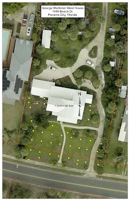
The image below produced by the Bay County GIS Department shows the location of 38 shovel test pits excavated at the G.M. West House site in Spring 2023. Bay County staff provided us with assistance in recording individual GPS coordinates and taking this aerial photograph of the site that they overlaid the point features to.


Comments
Post a Comment