Visibility Analysis
This week in GIS 5100, we learned about visibility analysis with a focus on two main types: viewshed and line of sight. As part of our assignment, we were directed to complete four different Esri courses through ArcGIS Online. This included: Introduction to 3D Visualization, Performing Line of Sight Analysis in ArcGIS Pro, Performing Viewshed Analysis in ArcGIS Pro, and Sharing 3D Content using Scene Layer Packages.
For the first course, Introduction to 3D Visualization, I learned about using local and global scenes, and their differences, cartographic offset, vertical exaggeration, extrusion and applying 3D symbology, and making visual enhancements, such as displaying shadows, adjusting altitude, and ambient occlusion.
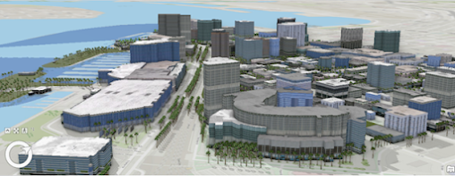
For one of this course's activities, I used an ESRI authored global scene of Downtown San Diego, CA, by applying 3D symbology. Here I was able to work with shadows, illumination, time of day and ambient occlusion. This was the most interesting scene I created for the module. I thought it was interesting how I could modify tree feature point symbology by selecting from a variety of pre-loaded tree choices; I added the "Mexican Fan Palm" per the instructions:
For the next course, Performing Line of Sight Analysis in ArcGIS Pro, I completed an exercise where I created a local scene showing visible locations of parade routes in Philadelphia, PA:
After this, I completed the third course, Performing Viewshed Analysis in ArcGIS Pro, where I created a local scene showing the hypothetical placement of two lighting systems at a campground at 3 meters and 10 meters above surface. The image below shows placement of lights for the latter:
For the final course, Sharing 3D Content using Scene Layer Packages, I learned how to share scenes created in ArcGIS Pro to ArcGIS online. I created a global scene in ArcGIS Pro of Downtown Portland, OR, with multipatch buildings, symbolized trees, an imagery basemap, and a digital terrain model (DTM) as the elevation source:
I then published this scene in ArcGIS online. The image below shows a screenshot of this opened in the scene viewer:
I enjoyed completing this week's lab activity very much, and it is one of my favorites in the certificate program so far. I liked creating the local and global 3D scenes and being able to publish these to an online platform to share the best. I have encountering may examples previously by colleagues in the field of archaeology that have stimulated my own curiosity and interest in completing my own projects of the like. This week's activity further reinforced my interest and provided me with some insight into how this process works. I still have much more to learn, but I believe this has given me a good foundation to continue my exploration into this ever expanding frontier in GIS.


Comments
Post a Comment