Data Quality: Standards
This week in GIS 5935 we continued our study of data quality in GIS with a focus on standards. This included metrics for assessing positional accuracy via standards such as the National Map Accuracy Standards (NMAS) and the National Standards for Spatial Data Accuracy (NSSDA). Positional accuracy is one of the five components of data quality with the others being attribute accuracy, logical consistency, completeness, and lineage.
For this module's lab assignment, I assessed positional (horizontal) accuracy for two different polyline layers of streets in a section of Albuquerque, New Mexico. This included a shapefile of road centerlines from the City of Albuquerque and another file of a sample of the same study area from StreetMap USA, a TeleAtlas product distributed by ESRI with ArcGIS. For the assignment, I created three different point shapefiles. Two were directly produced from a sample of 20 different intersections of streets in the previously mentioned polyline files. The third was a reference shapefile where I digitized the intersections from use of a series of orthophotos (2006) of the study area.
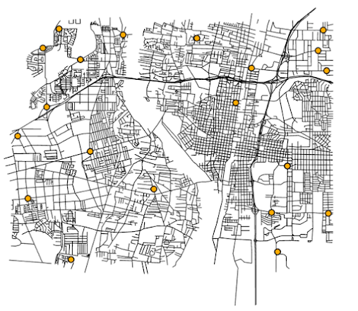
This screen shot shows the location of 20 sampling locations:
I calculated horizontal accuracy by determining XY coordinates for the 20 sample points in each of three different point shapefiles. Next, I exported this information to an MS Excel file in order to work with the data, such as computing the errors from the differences between each sample point and benchmark, as well as the mean, median, minimum, and maximum values of the squared sum of the errors. This allowed a calculation of the root-mean-square error (RMSE). Finally, I computed the NSSDA statistic which was determined by multiplying the RMSE by 1.7308, which is the value that represents the standard error and mean at the 95% confidence level.
For assessment
of Albuquerque streets sample data:
Tested 37.39 feet horizontal accuracy at 95%
confidence level.
For
assessment of StreetMap USA sample data:
Tested 423.71 feet horizontal accuracy at 95% confidence level.
Overall, the results indicate a much higher level of positional accuracy from the City of Albuquerque's data than that from ESRI, which was expected per the information in the instructions.
I found this week's topic and assignment interesting and helpful in expanding my knowledge in standards the use of geospatial data along with strengthening some of my existing skills such as digitizing ortho maps, and creating and editing point files.


Comments
Post a Comment