Land Use/Land Cover Classification/Ground Truthing and Accuracy Assessment
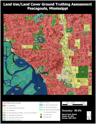
This week in GIS 5027, I learned about land use/land cover (LULC) classification, and ground truthing and accuracy assessment. For the lab assignment, I constructed a LULC map based on an aerial photograph of the northeastern area of Pascagoula, Mississippi. Here I recognized various elements and features that facilitated the classification. Following this, I conducted an accuracy assessment of the LULC classification by ground truthing data via Google Street View. Below is a map that shows 30 points created via the Create Random Points tool in ArcGIS Pro. Here I achieved 86.6% accuracy with the classification as 26 out of 30 points were verified as true:
This assignment was time intensive, but helpful in enhancing my skills in aerial photograph interpretation and digitization of features. I also found the exercise on accuracy assessment interesting as well, and I especially enjoyed the part that involved ground truthing randomly selected locations via Google Street View. I believe that the skills and techniques learned in this lab will be helpful in my own research in regards to investigating archaeological sites from aerial photographs.


Comments
Post a Comment