GIS Portfolio
I am proud to present my portfolio, which fulfills GIS Internship (GIS 5945), my final course for the graduate certificate in Geographic Information Science (GIS) at the University of West Florida (UWF). This may be the last entry to this blog, at least during the remainder of my time in the program. In this entry I will provide highlights from my portfolio and what I accomplished for the GIS internship along with some final thoughts on the program.
The primary goals for the internship related to my work as a professor at Gulf Coast State College (GCSC) in Panama City, Florida. These involved: developing a World Regional Geography with GIS course, producing site maps for GCSC archaeological research projects, and conducting basic spatial analysis. I shared information on progress on the first task in a previous entry (February 29, 2024), so here I will discuss the last two.
In the Spring 2015 semester, GCSC offered its first Introduction to Archaeology (ANT 2100) course, and accompanying this was an inaugural archaeology field program. Our project took place in the heart of Downtown Panama City, Florida on a privately-owned vacant lot that once was home to two historic hotels. The first of these was the Panama Hotel, built in 1912 and destroyed by fire in 1929. The second was the Edgewater Hotel, built in 1933 and demolished in 1970.
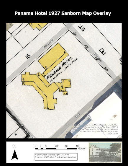
This map shows the footprint of the Panama Hotel from a section of the 1927 Sanborn Fire Insurance Company overlaying the current lot:
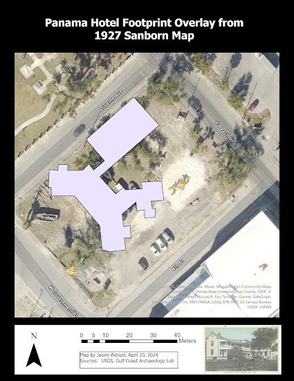
I digitized the footprint of the Panama Hotel as a polygon feature class overlaying an aerial image of the lot:
This map shows the results of our work from four different spring semester classes (2015 to 2018) that resulted in a total of 96 shovel tests excavated and three 1-meter x 3-meter test units:
This map uses a graduated symbol map to show the distribution of artifacts from shovel tests, by count, that show evidence of exposure to fire (such as burn marks, melting, etc.). Given that the hotel was destroyed by fire in 1929, I thought it would be interesting to explore this distribution in relation to the building's footprint. Here I used the raw counts and five classes with Natural Breaks (Jenks). It appears that most of the fire exposed artifacts exist outside of the building and this might be explained by patterns of demolition, and movement of debris across the property, the fire's source and spread, and the possibility that either the artifacts, or placement of the footprint on the site need re-examination.
You can learn more about this project and work at the Oaks Hotel from my portfolio. Additional information about the work I do with GIS and archaeology is on my ArcGIS StoryMap. Overall, I enjoyed completing the portfolio project, the internship, and the certificate program. I look forward to what the future holds in terms of research and teaching in GIS.


Comments
Post a Comment