GIS and Curriculum Development
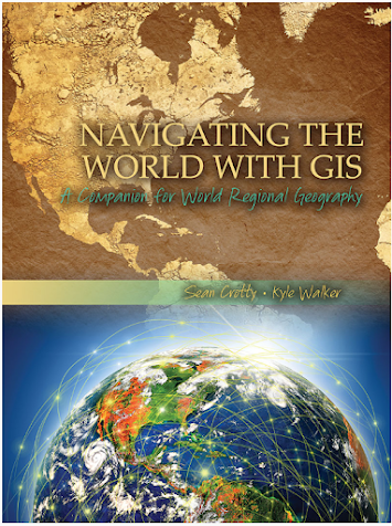
For part of my internship activities, I am developing curricular materials for use in World Regional Geography, a course currently proposed to be offered by Gulf Coast State College starting in Fall 2024 that I anticipate teaching. I have an interest incorporating GIS into class lessons and student assignments, and I have been exploring Navigating the World with GIS: A Companion for World Regional Geography (2015)
by Sean Crotty and Kyle Walker. I may assign this text as a companion along with Finlayson's World Regional Geography. Crotty and Walker's book includes nine chapters each with its own exercise. Topics include global population change, aging in Europe, political and ethnic geography in the former Soviet Union, segregation in North American cities, economic inequality and migration in Mexico, social and spatial context for the 2014 World Cup, combating Malaria in Ghana, electoral geography and the 2014 Lok Sabha elections, and mapping maritime disputes in the South China Sea. Data files are provided for eight exercises (except for the first chapter) via a USB jump drive that accompanies the purchase of the print copy of the book.
Following the textbook's introduction is a section that directs students to register with ArcGIS Online by creating a free public account. Chapter One introduces students to the basics of ArcGIS Online with a topic that covers Global Population Change in the 21st Century. The reader is directed to a website to access the map for the exercise. Unfortunately, the link is misprinted with a typo and when corrected, it directs the viewer to an unavailable page. I was, however, able to access the data for the exercise through the ArcGIS site that was created by one of the book's author's Kyle Walker: ch1_projections.
In Chapter One, students are introduced to basic demographic terms including population projections, fertility, mortality, migration, and projection variants as well as ArcGIS concepts and tools. The latter includes feature layer, attributes, legend, symbology, and basemap.
After the reader is provided with a passage on viewing and interacting with the ArcGIS online data, a set of review questions follow (eight short answer and 3 short essay). The first question reads "What part of the world is projected to grow the most over the next several decades? What part of the world is projected to experience the steepest population decline?"
Below is a screen capture of the main ArcGIS Online interface the students would use. After adding the assigned layer to the maps, they can retrieve demographic attributes from each country by either selecting it on the map or through the layer's attributes table.
The chapter also provides instruction on use of the filter tool, where the user can specify an expression that allows for retrieval of select records, such as countries with a population of greater than 1,000,000 in 2015 as seen in the screen capture below:
I plan to explore this textbook and its accompanying exercises further to determine whether or not I would adopt it for use in the new class. So far, I am satisfied with the style or presentation and material covered, aside from the issue with the broken link to the first chapter's map data. This can be overcome, however, by providing students with the layer directly. The book and the accompanying data is outdated at nearly 10 years, but many of the critical concepts pertaining to geospatial analysis and ArcGIS online remains. The data is also offered to students via a USB drive but I suspect most students might prefer to download directly online instead. As I continue to review the book, I will take note of what may need to be updated in the instructions regarding the use of ArcGIS Online. I could use assign this book as reference for basic use of ArcGIS Online but develop new assignments with a set of more recent data. I may also pass on the book and develop my own lessons that includes updated information for the latest version of ArcGIS Online. Regardless of how I decide to move forward, I am very excited about the use of ArcGIS online in my future course.


Comments
Post a Comment