Posts

GIS and Curriculum Development
Image
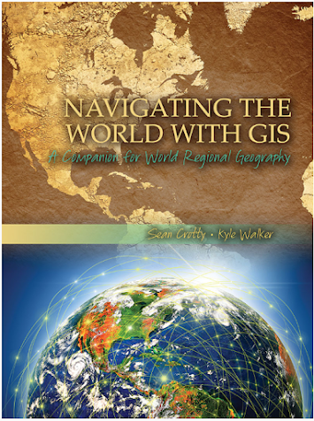
For part of my internship activities, I am developing curricular materials for use in World Regional Geography, a course currently proposed to be offered by Gulf Coast State College starting in Fall 2024 that I anticipate teaching. I have an interest incorporating GIS into class lessons and student assignments, and I have been exploring Navigating the World with GIS:  A Companion for World Regional Geography (2015) by Sean Crotty and Kyle Walker. I may assign this text as a companion along with  Finlayson's World Regional Geography . Crotty and Walker's book includes nine chapters each with its own exercise. Topics include global population change, aging in Europe, political and ethnic geography in the former Soviet Union, segregation in North American cities, economic inequality and migration in Mexico, social and spatial context for the 2014 World Cup, combating Malaria in Ghana, electoral geography and the 2014 Lok Sabha elections, and mapping maritime disputes in the So...
Readings for GIS Internship

Image
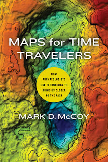
To support my internship, I ordered three books that I believe will be helpful in guiding my research and GIS-related activities. Maps for Time Travelers (2022) by Mark D. McCoy, professor of anthropology at Florida State University, is a recent book that provides a brief, but comprehensive exploration into the ways that archaeologists use geospatial technologies, particularly GPS, GIS, and various remote sensing techniques in the study of the human past.  In this work, McCoy provides an overview of the use of these technologies by archaeologists from early studies over a century ago up through the present time.  He discusses how these technologies can be used to understand human patterns of migration, food procurement and production, and how ancient societies can be "reversed engineered" through these approaches. While I am familiar with many of the technologies discussed in the book and some of the cases studies where they have been applied, this work serves a good refresh...

Internship Introduction and GIS Community

This semester I am excited to begin, GIS 5945:  Internship, which is the final course required for the Graduate Certificate in GIS at UWF. At the completion, I expect to have enhanced my knowledge and skills in using ArcGIS Pro software while incorporating basic principles of geography,  and local contextual archaeological and historical data to support GIS analysis. Key learning goals for the internship include: 1. Explore the distribution of geography/GIS courses taught in the Florida College System and preparing for teaching in geography with GIS at Gulf Coast State College. 2. P roduce maps for archaeological sites using ArcGIS that were studied by Gulf Coast State College. 3.   L earn how to conduct spatial analysis of archaeological data using ArcGIS. This week for the internship, I updated my C.V. to reflect some of the competencies in GIS I have obtained while taking courses in the certificate program.  In addition, I was directed to join a GIS user...

Remote Sensing Final Project

Image
I finished GIS 5027 with a final project that examined land use land cover (LULC) changes in South Lake Tahoe, California. I investigated changes in the distribution of impervious surface areas to assess the extent of urbanization by comparing European Space Agency (ESA) Sentinel-2 mission satellite data from 2016 and 2023. By using ERDAS Imagine and ArcGIS software, I created two final maps reflecting the work completed on my project.  The first map shows LULC derived from supervised image classification of the 2023 image of five distinct classes of landcover (Buildings, Forest, Lakes, Roads, and Wetlands).   It is estimated from this subset image that impervious surface comprises 42.4%, excluding the areas identified as “Lakes”:   The second map includes a false color urban RGB composite of the same 2023 subset image. This uses a combination of Bands 12, 11, and 4 displayed as R-G-B respectively. It clearly makes the vegetation (pervious surface) stand out in green from...

Unsupervised and Supervised Image Classification

Image
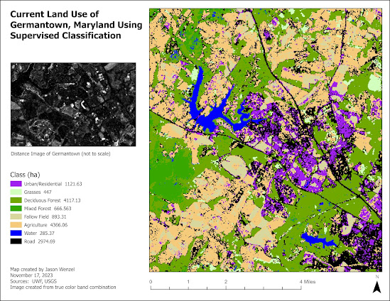
This week in GIS we covered unsupervised and supervised image classification where we conducted digital image processing in ERDAS Imagine software to collect and evaluate spectral signatures from satellite imagery. For the first part of the assignment, I conducted an unsupervised classification of surface types from a high resolution aerial photograph of the UWF campus in order to determine the amount of coverage of permeable vs. nonpermeable areas. For the the second part of the assignment, I conducted a supervised classification of land use of Germantown, Maryland based on a true color satellite image: Overall, I enjoyed completing this week's assignments and found the skills and techniques I learned helpful in expanding my proficiency in GIS.

Image Preprocessing: Spatial and Spectral Enhancements and Band Indices

Image
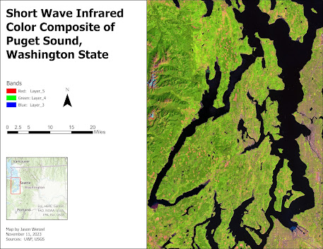
This week in GIS 5027, we learned about image preprocessing, specifically how to apply spatial enhancements for imagery use, and how to view the properties of multispectral imagery and create band indices. For the main part of the assignment I prepared maps of three different features in the vicinity west of the greater Seattle, Washington area, each using a different band combination. Working with the ERDAS Imagine software, and following the lab instructions, I identified these features from a LANDSAT Thematic Mapper derived image by following four steps:     1. Examined the histogram for shapes and patterns in the data.     2. Visually examined the image as grayscale for light or dark shapes and patterns.     3. Visually examined the image as multispectral, changing the band combinations to make certain         features stand out.      4.  Used the Inquire Cursor to find the exact...

Electromagnetic Radiation (EMR), Satellite Sensors, and Digital Image Processing

Image
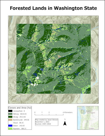
This week in GIS 5027, we covered electromagnetic radiation (EMR), Satellite Sensors, and Digital Image Processing. For the first part of the lab, I learned how to calculate wavelength, frequency and energy of EMR and use basic tools in ERDAS Imagine.   I created this map from a classified image of forested lands in Washington State.  By using the Inquire tool in ERDAS Imagine, I selected a subset from this and then calculated the size of each class (in hectares) via the creation of a new attribute column. After saving the subset as an output file, I imported it into ArcGIS, where I adjusted the layer's symbology with seven different classes, each showing its total area in the subset in hectares in the map's legend: For the second part of the lab, I learned about four different types of resolutions (spatial, radiometric, spectral, and temporal), their relationships with pixel and/or image size, and how to identify each in ERDAS Imagine.  For the exercise,  I exp...